SOUTH FORK KERN RIVER
Kennedy Meadows to Long Valley (5/4 - 5/5/96)
Rocky Contos ( )
The South Fork Kern, like the popularly boated North Fork Kern, is
unlike many other Sierra rivers in that it flows in a north-south direction
rather than an east-west direction. It lies to the east of the NF Kern and
meets it at Lake Isabella. Its headwaters tumble from elevations up to
almost 11,000 ft. However, the smaller drainage area and its more eastern
location in the Sierra give it a much smaller watershed than the NF Kern.
The season in which the river is boatable lasts from the first rains
(usually from December to February) to the time the snow melts away
(usually May- late June). Most of the river that has been boated lies at
high elevation (4000-8000 ft). The flow can be estimated by subtracting
"flow at Kernville" from "inflow to Lake Isabella". In the early-mid
spring, it seems to hold about 1/8 the flow at Kernville. This small river
has much to offer the adventurous whitewater paddler. There are about 60
miles of river from Monache Meadows to Lake Isabella.
The first generally acknowledged put-in lies at an elevation of ~8000
ft at Monache Meadow. There is a 4WD road into the meadow, though the pass
is blocked by snow until late spring. Last year it was open sometime in
June and this year is expected to be open early June. The gradient on
this 17 mile run is (in feet per mile):
| Monache Meadow to Kennedy Meadow (miles 69-52) |
10
|
10
|
10
|
10
|
10
|
10
|
10
|
50
|
100
|
180
|
230
|
200
|
250
|
225
|
165
|
140
|
25
|
25
|
This stretch apparently is best done in two days. The rapids are class V
in the gorge and consist of stircase-type drops. All drops supposedly are
runnable or easily portaged. At Kennedy Meadow there are a number of
houses/ranches and a small store (including gas). It is possible to drive
a passenger car into Kennedy Meadow most of the year, though the graded
dirt (good quality) road goes over a 7200 ft pass that could be blocked by
snow at some times. In Kennedy Meadow there are two bridges crossing the
river. The gradient of the river below here:
| Kennedy Meadow to Long Valley (miles 52-30) |
25
|
25
|
25
|
25
|
60
|
90
|
60
|
45
|
15
|
15
|
15
|
15
|
10
|
30
|
60
|
55
|
185
|
200
|
65
|
135
|
190
|
100
|
There is a small class III-IV gorge below Kennedy Meadow (miles 5-8 on this
run) before the river runs through the pleasant class I Rockhouse Basin (15
fpm section). Past Rockhouse Basin the White Dome towers over river right
as the water flows through narrow chasms with hugh granite boulder chunks
creating class V/VI rapids. This area is called the Domeland Wilderness.
The Long Valley trail (at the end of this run) follows a small creek on
river left up about 2 miles to a BLM campground. Total elevation gain is
about 600 ft. The campground has outhouses and water spigots, though they
had no running water when we were there. There is a good dirt road into
the Long Valley campground (turnoff from the fire/ranger station). It
takes about 1.5 hr to drive one way from here to Kennedy Meadow.
Below Long Valley the SF Kern makes its final spectacular class V-VI
plunge through the "Lower Gorge" before it turns to an east-west direction
and slowly reaches Lake Isabella.
| Long Valley to Lake Isabella (miles 30-10): |
80
|
125
|
225
|
240
|
340
|
380
|
200
|
110
|
70
|
45
|
25
|
25
|
10
|
10
|
10
|
10
|
10
|
10
|
10
|
10
|
This gorge has never been boated. Though one of the miles is 380 fpm, the
40 ft contours are fairly evenly spread through this mile. The 340 fpm
above it, however, consists of about 1/3 mile where the river is almost
flat, then plunges down 260 ft in less than half a mile. This extremely
steep section also lies at the bottom of an equally impressive gorge with
walls towering up on either side, making portaging perhaps very difficult.
Once the river reaches the flat valley, takeouts are possibe at numerous
locations, as highway 178 is not far from the river. A public bridge
crosses the river at Onyx, about 5 miles upstream of the bridge just before
Lake Isabella.
The first descent of the SF Kern (Royal Robbins, Reg Lake et. al.)
occurred in March 1986. Apparently this group started at Monache Meadows
using a helicopter put-in, and took out at Kennedy Meadows. The second
descent of this stretch was by Tom Moore (local Kernville boater and owner
of Sierra South) and Rick Haines, while a third descent occurred last year
(1995) by Ed Gordon, Brandon Prince, and Gary Gunder. Phil Martin et. al.
report running the Kennedy Meadow to Rockhouse Basin stretch several years
earlier. In late March (1996) Keith Dinger, Charles Foster, and Rick
Norman planned on boating from Kennedy Meadow to Long Valley in two days,
but upon reaching the class V/VI "White Dome Gorge" their second day,
decided to hike across the horseshoe bend of the river to the Long Valley
Trail (6 miles). This ended up taking an extra half day to get out (almost
three days total).
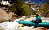
 Chip Childers and myself planned on doing the Kennedy Meadow down run
on the weekend of May 4-5. My grand scheme was to start very early
Saturday morning and make it to Long Valley that evening, where we would
hike out and car-camp. The next day we would do the more difficult Lower
Gorge, taking out at Onyx. Fortunately, we had a shuttle driver (Ruth, who
just wanted to get away alone somewhere to study all day). Unfortunately,
we didn't arrive at the put-in until 10 am. With the video camera deciding
not to work that day, I bought an $18 waterproof disposable camera at the
Kennedy Meadow store. We put in at 10:15 am by the lower bridge in the
meadow. Just above was a small class II drop. Just below was a barbed
wire fence. As a rough flow comparison, we could boat around the first
barbed wire on the left. There was about 500 cfs in the river that day.
A little below the put in is another barbed wire fence (this I carefully
boated through), and then after another mile, a third (which had to be
walked over). The first few miles were easy class I-II, with several fun
play waves. Before hitting the first small gorge with the 60/90/60
gradient, there were a couple calss III brush-choked rapids as well as a
couple 2-3 ft drops over beaver dams. All of these could be boat scouted,
though one might want to take a gander at the brushy class IIIs where one
has to go by instinct initially to get through.
Chip Childers and myself planned on doing the Kennedy Meadow down run
on the weekend of May 4-5. My grand scheme was to start very early
Saturday morning and make it to Long Valley that evening, where we would
hike out and car-camp. The next day we would do the more difficult Lower
Gorge, taking out at Onyx. Fortunately, we had a shuttle driver (Ruth, who
just wanted to get away alone somewhere to study all day). Unfortunately,
we didn't arrive at the put-in until 10 am. With the video camera deciding
not to work that day, I bought an $18 waterproof disposable camera at the
Kennedy Meadow store. We put in at 10:15 am by the lower bridge in the
meadow. Just above was a small class II drop. Just below was a barbed
wire fence. As a rough flow comparison, we could boat around the first
barbed wire on the left. There was about 500 cfs in the river that day.
A little below the put in is another barbed wire fence (this I carefully
boated through), and then after another mile, a third (which had to be
walked over). The first few miles were easy class I-II, with several fun
play waves. Before hitting the first small gorge with the 60/90/60
gradient, there were a couple calss III brush-choked rapids as well as a
couple 2-3 ft drops over beaver dams. All of these could be boat scouted,
though one might want to take a gander at the brushy class IIIs where one
has to go by instinct initially to get through.
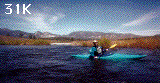
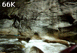
 We knew we were in the first gorge because the hills come close to the
river and the rapids come close together. I think we stopped to scout one
rapid in this stretch, which turned out to be only class IV. (PICT) In
general, this is a very fun class III-IV 4 mile stretch of river I highly
recommend. The river soon opens up into the wide, flat Rockhouse Basin.
Here one peacefully floats through about 7 miles of mostly class I. In the
distance one can see the beautiful White Dome on the right. Apprehension
grew as we drew closer to this chasm that Dinger et. al. completely
portaged. We were at the end of Rockhouse Basin by about 1:30 pm. The
canyon walls soon came next to the river. We could see the giant slabs
sloping up on either side. After running several easy boat-scoutable class
II-III rapids, we knew we were in the depths of the WHITE DOME when we came
to the particularly narrow region with the first class V. We dubbed this
first (second?) class V "South Fork Flush" due to its similar feel to Royal
Flush on the Lower Kern. Scouting initially on the right, I couldn't see
the entire rapid. Scouting on the left, which would have been an easy
portage route, gave a complete view.
We knew we were in the first gorge because the hills come close to the
river and the rapids come close together. I think we stopped to scout one
rapid in this stretch, which turned out to be only class IV. (PICT) In
general, this is a very fun class III-IV 4 mile stretch of river I highly
recommend. The river soon opens up into the wide, flat Rockhouse Basin.
Here one peacefully floats through about 7 miles of mostly class I. In the
distance one can see the beautiful White Dome on the right. Apprehension
grew as we drew closer to this chasm that Dinger et. al. completely
portaged. We were at the end of Rockhouse Basin by about 1:30 pm. The
canyon walls soon came next to the river. We could see the giant slabs
sloping up on either side. After running several easy boat-scoutable class
II-III rapids, we knew we were in the depths of the WHITE DOME when we came
to the particularly narrow region with the first class V. We dubbed this
first (second?) class V "South Fork Flush" due to its similar feel to Royal
Flush on the Lower Kern. Scouting initially on the right, I couldn't see
the entire rapid. Scouting on the left, which would have been an easy
portage route, gave a complete view.
We both ran it without incident, but just below and for the next mile was
class V after class V (about 8-10 total, short pools between them). The
granite slabs often came directly down to the river at 40-80 degrees. The
second major class V we dubbed "Peacock" due to a horribly beautiful
downstream rooster tail 2/3 down the rapid on the right. 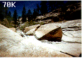 Just above this
was a small death channel to the left behind a huge granite boulder. As I
went down first, attempting to stay well away from the peacock, I was
slammed into the left channel. Though trivial to prevent my boat from
going further into it (it was rather flat there), I found it impossible to
turn my boat around and peel out into the current or move (backward)
upstream into the eddy further. I ended up peeling out backward, going
over the next 3-4 ft drop almost flipping. Chip apparently hit the same
eddy and problem, though flipped immediately, rolling up unscathed below
the peacock.
Just above this
was a small death channel to the left behind a huge granite boulder. As I
went down first, attempting to stay well away from the peacock, I was
slammed into the left channel. Though trivial to prevent my boat from
going further into it (it was rather flat there), I found it impossible to
turn my boat around and peel out into the current or move (backward)
upstream into the eddy further. I ended up peeling out backward, going
over the next 3-4 ft drop almost flipping. Chip apparently hit the same
eddy and problem, though flipped immediately, rolling up unscathed below
the peacock.
After one or two more class V, we came to a particularly impressive
one. A granite slab sloped down to the left side of the river at a 70-80
degree angle for over 100 yds. Out to scout on the right, we saw the rapid
to consist of about 4 drops. The left slab near the end of the rapid had
interesting carvings on it, including two curved lines making it look like
the slab was "smiling". We dubbed this rapid "Smiling Slab". It is a
class V similar to The Plank on the Cataracts of the Kern. The first move
we decided was to boof off a boulder "plank-like" chunk in the middle of the river, missing a large hole on the right and who knows what on the
left. After this was a couple more fast drops till the last one - ugly on
the left, nicer on the right, but below the right 5 ft sliding plunge the
current pushed you directly into some strainers. This I thought would be
the toughest part. I grabbed the throwbag, and Chip went to run it first.
To my dismay (and I'm sure his), Chip fell off the boof rock to the left
(into the unknown - actually a very deep hole). I watched for him to
appear below, but after 10 seconds I was really worried! Then I saw his
paddle float out and I knew he was in deep shit!! I scrambled downstream a
bit to set up a rescue and perhaps grab his paddle if I could. As he
floated out and downstream, he apparently went under a rock sieve. I
couldn't access him with the throw rope till the end of the rapid, where,
fortunately, he made it to the side, OK. He could get his boat as it came
down, so I decided to run down after his paddle, which came upon the next
class IV, then V, then V. I lost site of it, but continued running down
another 15 minutes, almost stepping on a rattlesnake in the process.
Defeated, I came back, seeing that Chip had gotten his boat to the side.
No paddle. Would he hand paddle for a ways? Could we get another paddle
at Sierra South that evening? He portaged the next couple class Vs as I
went up to portage my boat down with him. During my portage along one of
the 50 degree slabs, I lost footing and fell down, hanging on a tree. My
boat went down to the river and started floating downstream. I yelled to
Chip and scrambled down to him as fast as I could. A wonderful stroke of
luck hit us, as Chip had found his paddle in the eddy right there, and
incidentally, my boat floated into that at exact same eddy! I guess I had
lost track of the paddle at that spot and continued searching downstream.
The swim Chip had was his worst ever, and he was quite dazed from it -
"hallucinating" he said. After that spot we came upon the next several
class IVs and Vs, probably portaging another two or so (all at river
level).
 According to Chip: "The boof move was not a hard one, but did require a bit
of speed, and angle, as the plank did slant off to the undesirable (left)
side, into a tricky boat size chute. A bit too lacadaisically (sp?), I
slid off the left side, and under the plank rock, which on (much) closer
examination, was actually more of a 4 foot waterfall. My left side was on
the fall line, my right side on the plank rock, undercut enough to let my
boat slide under. Not being able to roll, I pulled a Mark Spitz, coming up
BEHIND the waterfall, holding on to the boat. A very soothing place to be,
if I was in a swimming hole, but I was unfortunately at the top of a very
long and tricky rapid. After some weaseling, I finally got out from behind
the falls, still holding on the the Invader. When my boat started to go
into a very nasty strainer-filled hole, I let it go, and proceeded to have
a sans-kayak run of the following rapid, full of holes, undercut rocks and
falls. My legs were battered by the time I reached the shore, and I was
glad to see my boat float by a minute later."
According to Chip: "The boof move was not a hard one, but did require a bit
of speed, and angle, as the plank did slant off to the undesirable (left)
side, into a tricky boat size chute. A bit too lacadaisically (sp?), I
slid off the left side, and under the plank rock, which on (much) closer
examination, was actually more of a 4 foot waterfall. My left side was on
the fall line, my right side on the plank rock, undercut enough to let my
boat slide under. Not being able to roll, I pulled a Mark Spitz, coming up
BEHIND the waterfall, holding on to the boat. A very soothing place to be,
if I was in a swimming hole, but I was unfortunately at the top of a very
long and tricky rapid. After some weaseling, I finally got out from behind
the falls, still holding on the the Invader. When my boat started to go
into a very nasty strainer-filled hole, I let it go, and proceeded to have
a sans-kayak run of the following rapid, full of holes, undercut rocks and
falls. My legs were battered by the time I reached the shore, and I was
glad to see my boat float by a minute later."
Soon we came to the area where the gradient noticeable slackened (the 65
fpm), but the trees in the river made the rapids class IV-V still. Many
occasions here the branches would whack us as we boated through the only
channels possible, sometimes going over drops several feet. At this point
it was getting a bit late (almost 6 pm), and we decided to hike out to Long
Valley from here. On the topo, the river in the next 4 miles goes around a
large horseshoe bend. We hiked over the ridge ( several hundred feet) and
up to the Long Valley Trail, picking ticks off our legs now and then. The
hike to the trail was about 2.0 miles (often through bushes and over
boulders), and then up to the campground another 1.5 miles or so. All in
all it took us 2.5 hrs, arriving at the pleasant site of the vehicle with
Ruth at 8:30 pm (just after dark). The hike was stenuous ( ...strenous
enough without any weight on our back, and would be horribly undesirable to
attempt it with boats on our shoulders, as Dinger et al, did...).
 We hiked back the next morning - getting on the water again at noon,
and did the remaining 3-4 miles (gradients 135/190/100). It started out
quite easy, with the most forested section of river we had encountered.
This stretch really bush-whacked us.
We hiked back the next morning - getting on the water again at noon,
and did the remaining 3-4 miles (gradients 135/190/100). It started out
quite easy, with the most forested section of river we had encountered.
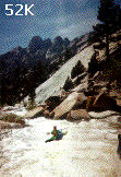
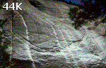
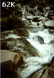
This stretch really bush-whacked us. 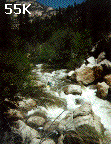 Soon the rapids became very
challenging with class Vs up to Taylor Creek (where the 190 fpm starts).
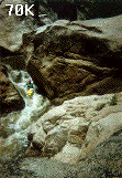
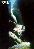
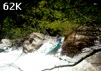
Pictures of several of these rapids are shown below. The first large one
encountered we portaged, but ran several nice class Vs after it.
Soon the rapids became very
challenging with class Vs up to Taylor Creek (where the 190 fpm starts).
Pictures of several of these rapids are shown below. The first large one
encountered we portaged, but ran several nice class Vs after it.
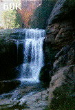
 We portaged maybe one more of the rapids in this stretch. At Taylor Creek,
we stopped to look at the waterfalls near the river. Beautiful 40 and 60
ft waterfalls lie on Taylor Creek shortly before it meets the SF Kern. It
is possible to climb up above the 40 ft falls, but would require
rock-climbing gear to get past the 60 ft falls (looked like the easiest
route up the chasm would be about a 50 ft 5.9 climb). There were 10 inch
fish IN BETWEEN the 2 waterfalls, which brings to mind questions of how
they come home to visit Mom once they've gone downstream.. Taylor Creek
was just an incredible place to be. I filled up my water bottle with the
creek water.
We portaged maybe one more of the rapids in this stretch. At Taylor Creek,
we stopped to look at the waterfalls near the river. Beautiful 40 and 60
ft waterfalls lie on Taylor Creek shortly before it meets the SF Kern. It
is possible to climb up above the 40 ft falls, but would require
rock-climbing gear to get past the 60 ft falls (looked like the easiest
route up the chasm would be about a 50 ft 5.9 climb). There were 10 inch
fish IN BETWEEN the 2 waterfalls, which brings to mind questions of how
they come home to visit Mom once they've gone downstream.. Taylor Creek
was just an incredible place to be. I filled up my water bottle with the
creek water.
 Below Taylor Cr were a few more class Vs which we ran, before coming to
unrunnable class VI for several drops. The portage started at a drop after
a pool in the river where there was a huge pile of wood floating into a
boulder. I paddled right up onto this "floating wood mass" and got out for
a scout. What I saw was not encouraging. Most water clearly poured over
to the right chute, which was not clearly visible from my perspective (and
wouldn't be from anywhere one could get out around there). Below were
several sieves.
Below Taylor Cr were a few more class Vs which we ran, before coming to
unrunnable class VI for several drops. The portage started at a drop after
a pool in the river where there was a huge pile of wood floating into a
boulder. I paddled right up onto this "floating wood mass" and got out for
a scout. What I saw was not encouraging. Most water clearly poured over
to the right chute, which was not clearly visible from my perspective (and
wouldn't be from anywhere one could get out around there). Below were
several sieves. 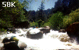 To the left the water poured over 6-10 ft falls with trees
in the middle. This was not possible either. What's more, there was no
portage at river level. The walls of the gorge here went nearly straight
up on the right side, while the left had a sloping 50-60 degree slab.
Perhaps at lower water one could portage at river level on the left. We
portaged up high on the left with ropes (several pitches - took an hour),
and got back down to the river to paddle another short pool before coming
to another sieve. This time we could portage on the left nearly at river
level and through a cave of sorts. Just below here there was no easy
access to the river. We were forced to seal launch down a 15 ft boulder
that was nearly vertical at the edge, making a vertical/front-flip landing
mandatory.
To the left the water poured over 6-10 ft falls with trees
in the middle. This was not possible either. What's more, there was no
portage at river level. The walls of the gorge here went nearly straight
up on the right side, while the left had a sloping 50-60 degree slab.
Perhaps at lower water one could portage at river level on the left. We
portaged up high on the left with ropes (several pitches - took an hour),
and got back down to the river to paddle another short pool before coming
to another sieve. This time we could portage on the left nearly at river
level and through a cave of sorts. Just below here there was no easy
access to the river. We were forced to seal launch down a 15 ft boulder
that was nearly vertical at the edge, making a vertical/front-flip landing
mandatory. 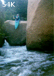 I launched in, nosed in deep, flipped and rolled up. Chip, who
launched in about 4 ft to the right of where I was, did the same thing, but
hit a submerged rock, tweeking his ankles out (they were not permanently
damaged, thank God!).
I launched in, nosed in deep, flipped and rolled up. Chip, who
launched in about 4 ft to the right of where I was, did the same thing, but
hit a submerged rock, tweeking his ankles out (they were not permanently
damaged, thank God!).
I went over the next small class II to a pool where the the river appeared
to go through sieves on 4 chutes. One chute in the middle looked
potentially doable. Attempting to get a better look at this possibly
runnable shoot, I was sucked backward into a brush/log/boulder sieve just
to the right of it. The boat was 1/2 underwater, nose pointing straight
up. I was stable and had no problem climbing out. The chute I thought
possible was clean. My boat was stuck. After 10-15 minutes of wiggling
with it, it was only going further underwater. I signalled Chip through,
handing me off the throwbag with his teeth as he went down the 2-3 ft wide
chute. I pulled my boat from the other way (river right - requiring me to
scramble up on an adjacent boulder), and it dislodged, going under the
sieve (I didn't know there was a passage underneath that big!). I threw
the rope in after the boat.
The boat bobbed up and down in the fast
current below the drop, and I thought it would come out in a few seconds.
Unfortunately, it just continued bobbing up and down! The rope had gotten
stuck in the sieve! We had no knife to cut it and I couldn't unclip the
biner with all that force pulling on it (not to mention the extreme
difficulty of getting down to it). I thought it might come loose after a
while, but it didn't after 30 minutes. I decided to hike out, leaving the
boat. Chip would paddle the remainder - he took off. As I tried climbing
up the walls on the left I was stalled for about 15 minutes. As I got
around and looked back down, my boat had dislodged. The biner was still on
the grab loop, so it seems the throwbag rope's knot had slipped. The
Extreme was folded in half downstream a little. To my surprise, the
disposable camera was sitting right next to the boat in the eddy (for your
viewing pleasure!). I eventually got the boat off and paddled it the rest
of the way, though still bent. This last stretch had lots of trees but was
generally class II-IV (except for two sieves which were definitely
unrunnable).
This last stretch Chip describes:
"My first portage was a class 5 rapid which I could not clearly survey
enoughto comfortably run. What I could see actually looked fun, with a
steep chute through some huge boulders. An easy portage on the left
beckoned, however, combined with my solo status, got me walking. At one
spot about a half mile from Long Valley, the river completely disappeared,
forming a little pond backed up by boulders and logs. Not a normal sieve,
I couldn't see any water flowing through at any point in this cul-de-sac.
After a confused survey of the scene, I seal launched off a huge log, 8
feet down between two boulders. The last half mile was class 3 water. I
carefully scanned the left bank for sight of the narrow Long Valley
creek,the topos Rocky had shown me of the monsterous canyons giving me
ample inspiration to not miss this turn off."
I hiked out the Long Valley trail, arriving at 8:30 pm. Chip had left his
boat 1/4 up the trail. He got it the next morning (Monday am) and thus we
were late getting back. My boat reformed to its original shape on the way
home (it was my first time using it!). Overall, I think this stretch of
the SF Kern is a wonderful expert run for those who like more
wilderness-type adventures. I'm planning on running the Lower Gorge when I
can find someone who would want to attempt it. It would probably require a
lot of shoulderwork!! Let me know if you're interested.
[ South Fork of the Kern | Preston's Kayak Page ]