
 The North Fork of the Kaweah river flows only a relatively short time in the early spring due to its lower drainage. The standard run begins at the confluence with Yucca Creek, and goes down to Paradise Flat. To this date the Upper North Fork of the Kaweah has been run only a handful of times. The first descent was by Rick Norman, Mike
Latendresse and Rick Penney in April of 1993. In the spring of 97 I had the opportunity run this section twice, the first with Keith Dinger and Keith Beck, and the second with Keith Dinger and Patrick Kruse.
The North Fork of the Kaweah river flows only a relatively short time in the early spring due to its lower drainage. The standard run begins at the confluence with Yucca Creek, and goes down to Paradise Flat. To this date the Upper North Fork of the Kaweah has been run only a handful of times. The first descent was by Rick Norman, Mike
Latendresse and Rick Penney in April of 1993. In the spring of 97 I had the opportunity run this section twice, the first with Keith Dinger and Keith Beck, and the second with Keith Dinger and Patrick Kruse.
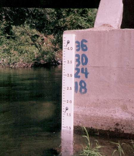
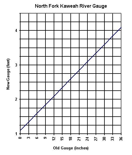
The only flow measurement is a gauge on the Bailey bridge, Bill Pooley provided the new gauge and the conversion chart for the old hand painted gauge (which is what was there for our runs). Our first run we had a pleasant 8 inches, the sescond time we had a fun with 6 inches, though some of the smaller drops were a bit boney. I'd guess this run would be good from 6-12 inches on the gauge, possibly higher depending on skill level. To get to the putin you first drive to the Yucca Cr confluence and park at the small turnout. Here there is the remains of an old bridge that crossed Yucca Cr. This is where you begin the 4 mile hike to the putin. We found a small wooden plank just down from the man made bridge that wee were able to cross Yucca Cr on. From here you then climb gaining most of the elevation for the entire hike as you traverse along a grassy slope. Crossing through several meadows the river seems far away, a few shaded turns in the trail are welcome cool spots. After this reltively short climb the trail follows a relatively even contour in open chapparal. The trail is mostly clear of brush and is easy footing on decomposed granite sand - but the river remains out of sight for a bit longer.
First you hear the river, then you catch a glimpse of a beautiful green pool. Further along you can see Burnt Point Creek spilling down some spectacular falls some 60 ft high. You will also get a glimpse of one of the great slides of the run, though you get a much better look of its right side boulder than you do of its overall elevation drop. About a mile after crossing Burnt Point Cr you get to a point where you can see the putin slide. We putin here both times, but Garry Valle and Gary Gunder who ran it this same season putin a mile above this - to try and put on any further up the trail they said was too choked with brush (on the slope, not the river) and too far away from the river. Though steep, the grassy slope down to this large slide makes a relatively easy way to get down to the river.
Be sure to check out the definitive Kaweah page by Bill Pooley
[Intro | Photo Index | rapids | Maps | Preston's Kayak Page ]