Never heard of it? Not too surprising. The San Dieguito river is normally not much more than a trickle here in San Diego. But when the spring floods come, we found there is water to be had.... if you don't mind a little strainer.
(Rocky's contributions appear as blockquotes)
The upper section as the river comes out of the Cuyamaca mountain range is little more than a narrow steep creek. Since there is rarely much water flowing, it was really choked with vegitation. It was a little more than I was willing to attempt, but Rocky was game for it:"The upper drainage of the river is in the Santa Ysabel range at a max. elevation of about 4000-5000 ft (between Mt. Palomar and Cuyamaca Mtn.). The first place we put in was on Santa Ysabel Creek, the main creek that forms what is called the San Dieguito River (which officially starts a little above Lake Hodges). After having paddled the section from the 78 bridge down to San Pasqual Battlefield the day before, I wanted to check out more upper sections. So we drove up another 2-3 miles and saw definite rapids!! I was extremely excited. We boat-hiked down the valley to the water (Santa Ysabel Cr.) and upon seeing it, Preston decided it too dangerous due to the strainers and rapids. The flow was probably ~400 cfs at the put-in. I certainly didn't want to carry my boat back up so told him my plan and took off!!! Getting in my boat, I was very anxious: paddling it alone, never having scouted it, with lots of brush and definite falls ahead.I peeled out into the water - siltiest I've ever seen - and caught an eddy first behind a rock, then behind a fallen tree. The water was swift, and precise maneuvering was required around the trees and bushes, but it seemed all boatable. After a hundred yards I was forced to scout: a 3-5 ft. drop and no path through the strainers below it could be seen from river level. From the side I could pick out a route, and subsequently pursued it. Another 1/4-1/2 mile and I came to another drop that definitely needed scouting. From the scout I could see what was below - pretty clean initially then small trees throughout the creek bed. The drop was obscured from where I was scouting, but looked about 5-6 ft. I got in and paddled it. Upon going over the lip I was dismayed to see a large chocolate hole just below with a rock on the left side of it, frothing up with backwash several feet above the creek. Trying to miss the left rock, I hit it slightly sideways and flipped. This was a scary event - perhaps getting stuck in a rock filled hole with strainers to the sides and downstream. I thought to myself, this might be it.
After only one or two roll attempts I thought my best bet was to exit and swim to the side. I did this, but getting out at the side was difficult. The current swooped past bushes and tree limbs lining the side with no good landing spot. I clung onto a branch keeping hold of my boat and paddle all the time. It must have been a couple minutes before I managed to push the boat up on the trees and secure it before I climbed over. It was fortunate, but there were definite deadly consequenses around with a wrong move. After emptying my boat I got back in and paddle the next couple miles to the bridge where Preston was already in his boat. That drop I flipped in was the worst of it. There were a few others - some nice play spots, but nothing that needed side-scouting."
 The middle section in the valley wasn't as exciting as we had hoped. I met Rocky at the bridge where the water was a rich brown from all the erosion and the banks had worn back so far that we saw several trees fall into the river as the soil was eaten from under them. Rocky had been there a couple days earlier:
"A friend of mine, Tibor Varga, was on the bridge snapping photos for the water district which he works for. He's been trying to get kayaking legal on Lake Hodges and other streams/lakes in San Diego county. Preston and I paddled the couple miles to the battlefield. The water was about a 3 times lower than when I had done it a day before, but there were still some nice "sand waves." These are curious rapids that form on very silty rivers where the sand on the bottom actually form depressions and ridges perpendicular to the current.The day before I had seen some get 4-5 ft. in height, sometimes even breaking. The most interesting thing about them is that they're temporary. One looks over the river and sees only swift water at one time, then turns around againin a minute and sees this huge wave!!! They also move upstream slowly and last on average a minute or two. The day before I rode a breaking sand wave sideways - it was just like playing in a hole, but it goes away if you can outlast it (almost like an ocean wave)."
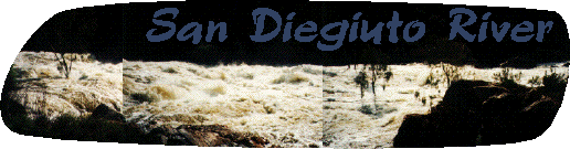
 The San Diegiuto is dammed at lake Hodges. Normally there is little to no flow below the dam. However today, it was spilling like crazy. The banner picture at the top of the page shows the water right below the dam. It was solid white and had a number of monster holes.
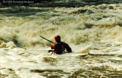
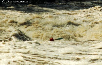
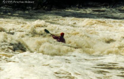
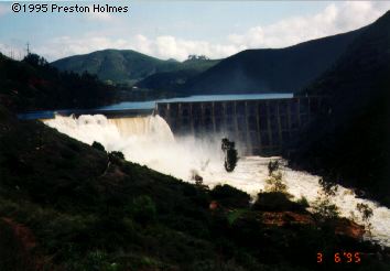
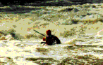
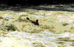
I was ecstatic at the flow we observed spilling below Lake Hodges - estimated 3000-4000 cfs. I couldn't let this one pass. I carried my boat down to the river level a little below the dam, past several killer holes big enough to hold several kayaks. There was a crowd of people gathered up on the road watching the water spill over. I knew a couple other boaters that had run this stretch down to the ocean two years ago when the dam was spilling before (at a lower level though), with a couple portages. Before that, the dam probably hadn't spilled for the length of the drought, 6 or so years. From the road there seemed to be passable channels on the right through the eucalyptus forests just below where I put in. I got in my boat and peeled out again. There was a killer hole on the right and left of the river with a small passage down the middle where it was more of a wave. The water was extremely swift, and I had to work very hard to get my boat out in the middle - I almost didn't make it. The sequence of pictures here shows me going through this first drop, actually hitting it cleanly in the center where there wasn't substantial backwash. Had I been to the right just another five feet, I would have hit the monster and been stuck.
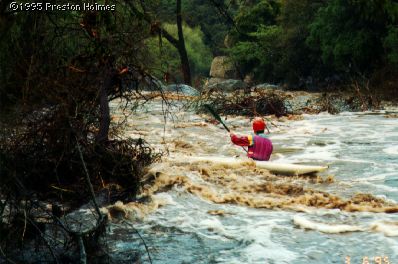
After this drop I paddled back to river right after gazing down at the forest just downstream. There was no visible path through. It looked exceptionally treacherous, with the water hitting the tree stems and forming pillows a few feet high. Quick technical maneuvering was the key here. After scouting from the side, still not 100% sure of thing farther below, I went for it. Luckily I made it through the forest and continued on, not quite as many trees in the next section. Looking at this section two days earlier with only minimal water I knew there was going to be one monster drop on river left coming up.
Paddling down to that was a fast roller-coaster like ride!!! There were at least 3 huge holes I missed by quick boat scouting. Fortunately I stayed on river-right when I reached the biggest of them all: THE KILLER. Though this hole hasn't actually killed anyone (that I know of), at these flows if some unfortuanate person floated into it, it would surely be their demise. It was a 6 ft. frowning pourover drop covering the left 1/2-3/4 of river into a full hydraulic maelstrom. Very scary. I got out below this awesome sight and rejoiced at my safe passage around it. (I actually ran through the KILLER two days after, at lower water [500-1000cfs], which did end up flipping me but not keeping me in it.) Preston and an LA Times photographer were on the road at the right side of the river. I talked to them and secured a ride from somebody who would go downstream 10-15 miles. Preston had to leave. I wrote the following to Preston when I returned to lab that day:
After you left, I continued down almost to the ocean - I took out below the bridge upstream of I-5 (El Camino Real). There was, downstream from where you last saw me:
- some more foresting in several places; always could find a channel through though was a bit scary at times; I'd say class IV skills required for the maneuvering
- one nasty V+ (maybe should be a VI); This must have been a low water bridge or a small dam somebody built across the whole river bed. The water sneaks up on it and it appears from above the drop that it would just be a large swooping wave. I took the chance (bad decision, without scouting) and plunged down the 4-5 ft. drop into the hole below (very much so a river-wide reversal; one bank to the other). I did almost get all the way out of the sucking reversal, but not quite, and the backwash turned my boat sideways as I tried desperately to paddle out of it. I was not in the hole proper, but just on all the white where half the flow goes back and the other half downstream. I couldn't turn my boat straigt and paddle out because the back would have gone in the hole and I would be sucked in. I ended up just paddling along the hole to the bank, skirting disaster in the precarious situation I was in, and managed to catch some swirling eddy going partially downstream. Grabbing onto a branch on the side also helped some, and I got out that way. This was probably the second scariest thing that happened to me today. If it were a low water bridge it would be a flushing hole (down below) and I could probably have escaped if, when upside down in it, I reached down with my paddle to grab the flushing water. But if it were a dam - there is no escape once in it. One can't tell from the surface what this was - I'd like to go back when the water is down and check it out again.
- a few great play areas; one with a string of standing waves like the Kings - 6 ft. some of them, in an open part of the river with no obstructions around; I didn't play around long in any of them as I was in a rush to get downstream and secure a ride back upriver
- a few miles of flat moving water to the bridge where I took out (there is another bridge it all goes under a couple miles up from where I took out - this would be fun for beginners to do)
It was really fun. I met the reporter guy on the road after I stopped and hiked out to Via de la Valle Rd and stuck my thumb out a couple minutes. He was walking around there taking more photos of the flooded polo field area. What was his name (Dan something or other)? He asked a bit more info from me, and gave me a ride back up to my car. I got back home around 1 pm and was in lab before 2 pm. I'm sure the San Luis Rey is cooking. Want to check that out manana? Also the great drainage area of the Santa Ana River near Irvine (probably an hour and a half drive) would be fun to check out. I might be hosting this prospective tonight though (I'll let you know). I should call up that photographer guy and buy the pictures he snapped.
As you can tell, S. California storm running isn't for everyone (it wasn't for me this year), but for those of us that are stuck with such long drives to get to the "real" rivers it is nice to have a little fun locally.