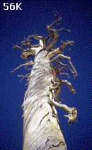
 Dinkey Lakes Wilderness located east of Fresno California is a gem of the Sierras. Multiple high mountain lakes all close together and each nested into the mountains at a different elevation.
Preston Holmes July 1999
Dinkey Lakes Wilderness located east of Fresno California is a gem of the Sierras. Multiple high mountain lakes all close together and each nested into the mountains at a different elevation.
[clicking on the small photos will enlarge the image in a separate window]
We did a three day trip there over the July 4th weekend, not exactly the least crowded time of year, but far less crowded than other places on that weekend. The drive to the trail head follows the classic Sierra approach pattern I'm used to. Get through LA, several hours of flatness on 99, small valley roads with lots of stop signs, a 'foothill' highway, followed by one or more small paved roads, to a falling apart paved road, to a dirt road. Dinkey Lakes is no different. The dirt road portion is much nicer than the part that was once paved and is now falling apart with deadly potholes waiting in the blind spots of the shadows.
Loading our packs quickly under the pressure of late morning mosquitos, we shared the parking lot with some rowdy 4-wheelers who were getting ready to do the "Swamp Route" a long 4WD track that has a trailhead adjacent to the Dinkey Lakes trailhead. The trail crosses Dinkey Creek almost immediately and follows it up towards a junction with First Dinkey Lake towards the left, and Mystery Lake towards the right. We headed up towards First Dinkey Lake which has a more continuous gradient than the other branch. First Dinkey has the largest grassy wetlands of any of the lakes, but a afternoon breeze let us stop for a quick lunch without many mosquitos.
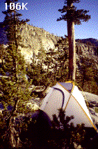
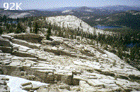
Continuing on to Second Dinkey Lake the trail starts to climb steeper, but not for long. We cut over and camped on an exposed granite ledge to the northwest of second Dinkey and was right next to a large granite monolith. This ledge had some nice flat spots for a tent and a spectacular view over South and First Dinkey Lakes below and the Kaiser ridge in the distance.
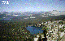
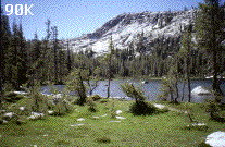
The next day was a layover day just to explore the area. The amount of granite and low density forests makes it excellent country for cross country exploring. The lakes are clustered in a relatively small area, so you can do plenty of poking around in just a few miles. Here is a map of the route we took. From our camp we took the short steep trail up to Island Lake, the highest of the lakes. Here snow was still along the banks. The outlet of Island lake tumbles steeply down towards South Lake and ends in a cascade only visible from the shores of South Lake. We continued around the shore of Island lake, but then cut cross country to the NW following a largely open ridge that provided some more sweeping vistas. We traversed down a forested slope toward Fingerbowl lake, using the granite wall I knew to be above Fingerbowl as a guide point. Fingerbowl is a small round lake with a marshy outlet on one side, and the snow a scree slope of the Three Sisters on the other.
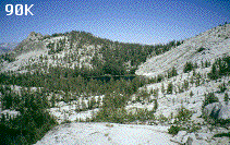 We climbed back up to the south edge of Island lake and followed its inflow up through some long narrow meadows with small stunted pines and a tiny little lake at the head just this side of the ridge demarcating the drainage limit. From here it was a straight scramble towards the 10196 peak to the North, just a steady walk up several hundred feet toward whatever was highest and we found ourselves at the top pretty quickly.
This was the most pleasant surprise of the whole weekend. I expected that we would have good views of Dogtooth Peak, and Cliff Lake, but we were in an excellent vantage point to look all the way across Courtright reservoir into the Granite features of the John Muir Wilderness. In fact the air was so clear that we could see the entire Sierra Crest to its southern extent, obscured only by nearby Eagle Peak. There was also not a mosquito to be seen, so we took a short nap and had lunch.
 From here we were able to cut across large fractured slabs of granite back towards the monolith/dome above our camp. There were all sorts of neat gullies in this section and good views down to Rock Lake. We cut back across the Island Lake Trail and headed up the large granite face of the monolith, something we should have just done at the start of our hike. It offered similar views over First Dinkey and South Lake as our campsite, but had great views of Dogtooth Peak and the large granite faces above Little Dinkey Lake (The only lake in the system we didn't get a good look at).
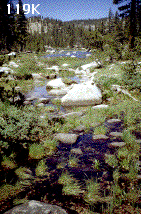 Our hike out started with a bit of a fumble in route finding cutting down prematurely to the bank of First Dinkey Lake, but then finding our way from the creek flowing between South and First Dinkey for the alternate return route. This short stream was among the prettiest of the area. From South Lake we could look up to where we were camping, and also see the inflow from Island lake cascading down the cliffs.
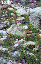
From here the trail stairstepped down through some wonderful wildflowers and then along Swede Lake. Another short steep step down toward Mystery Lake with lots of marshy area around it. The trail soon reconnected with the trail we had come up and even more wildflowers had burst onto the scene since we had hiked in 2 days earlier. Just before reaching the trailhead you can see a large grey rock to the west. If you cross over this rock you will find a small waterfall (unfortunately without a good swimming hole). Which is a great last glimpse of the beauty of the region before returning to the parking lot where the 4wheelers wait.